-
Kaleidoscope Image of Log Cabin Picnic Shelter, Morris-Erickson County Park – Chippewa Falls, Wisconsin
©2018 John Wanserski for Creative Juice LLC
©2011 John Wanserski for Creative Juice LLCBlog entries for Morris-Erickson County Park
Blog entries for Chippewa County
Weather forecast for New Auburn, Wisconsin vicinity
-
Reservable Picnic Shelter, Harrington Beach State Park – Belgium, Wisconsin

©2012 John Wanserski for Creative Juice LLCMap of Harrington Beach State Park (PDF File)
Reservable Shelters at Harrington Beach State Park
Reservable Open Shelters at Wisconsin State Parks
Weather forecast for Belgium, Wisconsin vicinity
Blog entries for Harrington Beach State Park
-
Welcome Center, Harrington Beach State Park – Belgium, Wisconsin
-
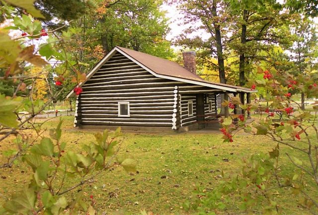
Log Cabin Picnic Shelter, Morris-Erickson County Park – Chippewa Falls, Wisconsin

©2011 John Wanserski for Creative Juice LLCBlog entries for Morris-Erickson County Park
Blog entries for Chippewa County
Weather forecast for New Auburn, Wisconsin vicinity
-
Picnic Shelter No.1 (Urban Pond), Richard Bong State Recreation Area – Kansasville, Wisconsin
©2010 John Wanserski for Creative Juice LLC
Richard Bong State Recreation AreaMap of Richard Bong State Recreation Area
Reservable shelters in Wisconsin State Parks and Forests
Weather forecast for Kansasville, Wisconsin vicinity
Blog entries for Richard Bong State Recreation Area
-
Riverview Picnic Shelter, Lake Wissota State Park – Chippewa Falls, Wisconsin
©2010 John Wanserski for Creative Juice LLCMap of Lake Wissota State Park
Reservable shelters in Wisconsin State Parks and Forests
Water activities at Lake Wissota State Park
Weather forecast for Chippewa Falls, Wisconsin vicinity
Blog entries for Lake Wissota State Park
-
South Picnic Shelter, Buckhorn State Park – Necedah, Wisconsin
©2010 John Wanserski for Creative Juice LLC
Buckhorn State ParkReservable shelters in Wisconsin State Parks and Forests
Weather forecast for Necedah, Wisconsin vicinity
Blog entries for Buckhorn State Park
-
Welcker’s Point Shelter, Peninsula State Park – Fish Creek, Wisconsin
©2010 John Wanserski for Creative Juice LLC
Peninsula State ParkPicnic Shelters in Wisconsin State Parks and Forests
Weather forecast for Peninsula State Park vicinity
Blog entries for Peninsula State Park

