My Wisconsin Space

Wisconsin Campgrounds, Wisconsin State Parks, National Parks and Monuments, Sacred Spaces

  • Home
  • A-Z List
  • Coffee Houses
  • Park & Campsite Videos
  • About
  • Home
  • A-Z List
  • Coffee Houses
  • Park & Campsite Videos
  • About

No Widgets found in the Sidebar Alt!

  • Ancient Peoples,  Other States,  Picture of the Day

    Part of the Besh Ba Gowah Pueblo at Besh Ba Gowah Archeological Park – Globe, Arizona

    May 8, 2011 /


    ©2011 John Wanserski for Creative Juice LLC

    Besh Ba Gowah Archeological Park

    Besh Ba Gowah Archeological Park, c1998 James Q. Jacobs

    Weather forecast for Globe, Arizona vicinity

    Blog entries for Besh Ba Gowah Archeological Park

    Videos of other parks, A-Z List , Locator Map

    Share on FacebookShare on Facebook

    read more
    Traveler John 0 Comments
  • Ancient Peoples,  Nat. Park/Forest,  Other States,  Picture of the Day

    Inside a Sinagua Pueblo, Tuzigoot National Monument – Clarkdale, Arizona

    August 31, 2010 /


    ©2010 John Wanserski for Creative Juice LLC
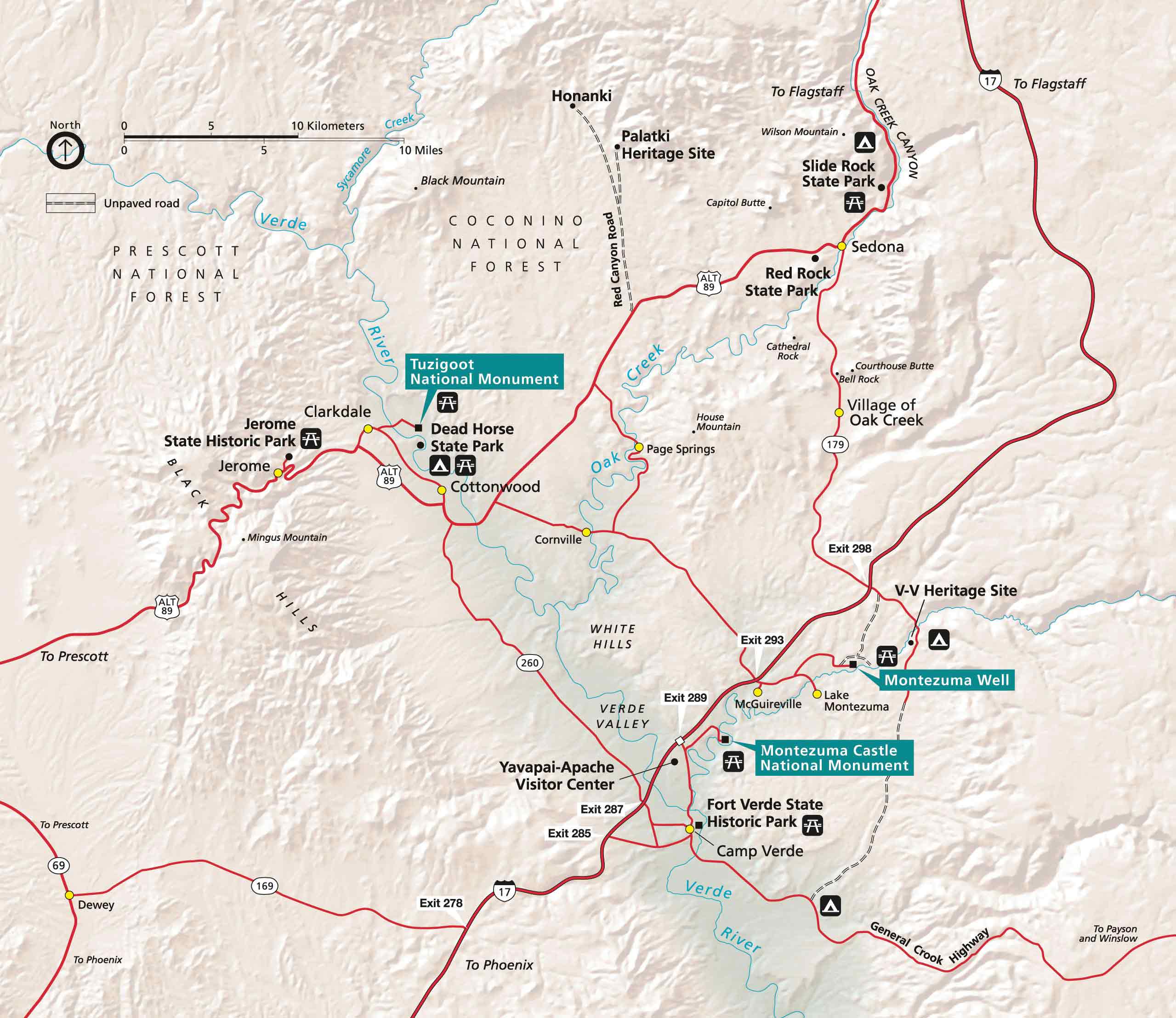
    Tuzigoot National Monument

    Tuzigoot National Monument area map

    The Sinagua People (from Anthropology Laboratories of Northern Arizona University)

    Weather forecast for Clarkdale, Arizona vicinity

    Blog entries for Tuzigoot National Monument

    Videos of other parks, A-Z List , Locator Map

    Share on FacebookShare on Facebook

    read more
    Traveler John 0 Comments
  • Ancient Peoples,  Nat. Park/Forest,  Picture of the Day

    Tyuonyi Pueblo, Bandelier National Monument – New Mexico

    September 8, 2008 /

    Bandelier National Park

    Banelier National Park video

    IPod videos of other parks

    Share on FacebookShare on Facebook

    read more
    Traveler John 0 Comments
  • Ancient Peoples,  Nat. Park/Forests,  Trails,  Videos

    Video of Far View House – Mesa Verde National Park, Colorado

    July 12, 2008 /

    Ancestral Puebloans lived at Far View 200 years before the Mesa Verde cliff dwellings were built. Approximately 50 villages existed over time within a half mile area of each other. Peak populations on this site occurred between A.D. 900-1300. Six excavated sites are connected by trails; Far View House, Pipe Shrine House, Coyote Village, Far View Reservoir, Megalithic House, and Far View Tower. Slide copyright 2008, Creative Juice LLC.

    Mesa Verde National Park

    Jesse Walter Fewkes

    J. Walter Fewkes – Wikipedia entry

    IPod videos of other parks

    Share on FacebookShare on Facebook

    read more
    Traveler John 0 Comments
  • Other Places,  Videos

    Video of Santa Fe, New Mexico

    March 7, 2008 /


    ©2007 John Wanserski for Creative Juice LLC

    Santa Fe lies in the Sangre de Cristo Mountains, the foothills of the Rockies. The ancient Indians who settled here thousands of years ago,the Spanish colonists who established a frontier town circa 1610 and the millions of visitors today understand that Santa Fe is a magical place. Back in 1912, in recognition of the city’s unique heritage, officials enacted laws requiring that structures be built in historic Pueblo Revival and Territorial architectural styles. Outside Magazine recently chose Santa Fe as one of the 30 Best Towns in America. It is one of the 1,000 places to see before you die.

    Weather forecast for Santa Fe, New Mexicon vicinity

    Blog entries for Santa Fe, New Mexico

    Videos of other parks, A-Z List , Locator Map

    Share on FacebookShare on Facebook

    read more
    Traveler John 0 Comments
  • Ancient Peoples,  Cliff Dwellings,  Nat. Park/Forests,  Trails,  Videos

    Video of Bandelier National Monument, New Mexico

    February 26, 2008 /

    Adolph Bandelier, the first anthropological scholar of the southwest, explored Frijoles Canyon, New Mexico in 1880. The oldest site in Bandelier National Monument dates back to 2010 B.C. Around 1100 A.D. Pueblo Indians began inhabiting Frijoles Canyon and the Pajarito Plateau. Around 1300 A.D. about a dozen large villages existed in the area. One of them, Tyuonyi, is accessible within the Monument near the visitor’s center. The remnants of cliff cave dwellings dug into the volcanic tuft, along the canyon walls, suggest an extensive multi-story village. Some of these Pueblo structures with labyrinths of caves and rooms were occupied for over 400 years. Approximately 3,000 archaeological sites are being documented within the Monument. An unexcavated village, Tsankawi, lies 11 miles away in a separate section of the Monument. The pueblos and cliff cave dwellings were vacated in the 1500’s. Part of the Monument has wilderness designation. Visitors can overnight in the backcountry with a permit. Family and group campgrounds are also available.

    Share on FacebookShare on Facebook

    read more
    Traveler John 0 Comments
Newer Posts 

Random Entry

Bird Mound, Devil's Lake State Park - Baraboo, Wisconsin

Created By Bunk Beds

Purchase Prints of My Sacred Spaces

Art Prints

Wisconsin Books

Categories

  • Ancient Peoples (292)
    • Cliff Dwellings (141)
    • Mound Builders (36)
  • Books (16)
  • Campsites (176)
    • .Wisconsin Sites (135)
    • Other Sites (41)
    • Walk-In Sites (29)
    • Water Access (40)
  • Coffee Houses (806)
    • Madison Coffee (167)
    • Other Coffee (259)
    • WI Coffee (547)
  • Maps (174)
    • Other Maps (49)
    • WI Maps (125)
  • Picture of the Day (6,139)
    • Kaleidoscope (205)
    • Kayak Waters (1,140)
    • Nat. Park/Forest (1,379)
    • Other States (2,994)
    • Wisconsin (2,909)
  • Uncategorized (1)
  • Videos (150)
    • Campgrounds (92)
    • County Parks (6)
    • Nat. Park/Forests (28)
    • Other Places (7)
    • State Forest (27)
    • State Park (81)
    • Trails (20)

+ WI Earth Links

  • – WI State Parks
  • Aldo Leopold Foundation
  • Aldo Leopold Legacy Trails
  • Apostle Islands
  • BirdCast
  • Botanical Club of WI
  • Chequamegon-Nicolet
  • Creative Juice LLC
  • Daycreek.com
  • Discover Wisconsin
  • Door County Land Trust
  • Earth Spaces – YouTube
  • Earthspace Twitter
  • Fishing Forecast
  • Friends of WI State Parks
  • Gathering Waters
  • Gaylord Nelson Wilderness
  • Glacial Lakes Conservancy
  • GLIFWC
  • Great Lakes Forever
  • Great Lakes Maps
  • Great Lakes Nautical Charts
  • Great Lakes Waterfalls
  • Ice Age Trail
  • Ice Age Trail Alliance
  • Kickapoo Valley Preserve
  • Lake Michigan Water Trail
  • Lakeland Aerial Photo
  • Lower WI Riverway
  • Mississippi River Charts
  • Mississippi River Trail
  • Native Am. Tourism of WI
  • Natural Heritage Land Trust
  • Nelson Institute
  • Olbrich Botanical Gardens
  • Prairie Enthusiasts
  • River Alliance of WI
  • Sigurd Olson Environ. Inst.
  • St. Croix Scenic Riverway
  • Teardrop Campers
  • The High Ground
  • Travel Green Wisconsin
  • Travel Wisconsin.com
  • Trees of Wisconsin
  • Troy Gardens
  • UW Arboretum
  • UW Press
  • UW Press WI Books
  • UW Sea Grant Institute
  • Wendt Library
  • WGNHS
  • WI Academy
  • WI Beach Health
  • WI Bear
  • WI Bike Trails
  • WI Bird Conservation
  • WI Birding & Nature Trails
  • WI Blue Book
  • WI Campion Trees
  • WI Canoe Heritage Museum
  • WI Coastal Atlas
  • WI Cougar Sightings
  • WI County Forests
  • WI County Parks
  • WI Covered Bridges
  • WI Dark Sky Sites
  • WI DNR Maps
  • WI Elk Herd
  • WI Endangered Resources
  • WI Fall Color Report
  • WI Fishing
  • WI Geography & Climate
  • WI Historic Sites
  • WI Historical Markers
  • WI HomeTownLocator
  • WI Horse Trails
  • WI Indian Mounds
  • WI Lake Maps
  • WI Land Trusts
  • WI Magazine of History
  • WI Maritime Trails
  • WI Minerals Database
  • WI Museums
  • WI Nat. Hist. Landmarks
  • WI Nat. Natural Landmarks
  • WI Nat. Res. Foundation
  • WI Nat. Wildlife Refuges
  • WI Natural Areas
  • WI Natural Resources Mag
  • WI Nature Conservancy
  • WI North Country Trail
  • WI Record Fish
  • WI Recreation Trails
  • WI Rustic Roads
  • WI Scenic Byways
  • WI Shipwrecks
  • WI Snow Report
  • WI State Cartographer
  • WI State Climatology Office
  • WI State Herbarium
  • WI State Historical Society
  • WI State Wildlife Areas
  • WI Statistics
  • WI Turkeys
  • WI Water
  • WI Water Trails
  • WI Weather
  • WI Wetlands Association
  • WI Wilderness
  • WI Wolves
  • WisconsinView
  • WOJB Radio

~ Earth Links

  • America's Quietist Routes
  • Backroads
  • Ctr for Sustainable Destinations
  • Daycreek.com
  • Earth Porn
  • Earthspace Twitter
  • Fishing Forecast
  • Google NGram Viewer
  • Historical Marker Database
  • iLike
  • Intern’l Dark Sky Assn.
  • LandScope America
  • Live Music Archive
  • Mississippi River Trail
  • NASA Earth Observatory
  • Nat. Hist. Landmarks
  • Nat. Register of Hist. Places
  • National Geographic Soc.
  • National Map
  • National Park Maps
  • National Park Service
  • National Parks (PBS TV)
  • National Parks Traveler
  • National Recreation Trails
  • National Scenic Byways
  • National Trails System
  • Native Tourism
  • Nature Conservancy
  • NatureServe
  • Nelson Institute
  • North Country Trail
  • Photosynth
  • Picture Gallery
  • Ramsar List of Wetlands
  • S. Arizona Nonprofits
  • Search-Cube
  • Shades of Rez
  • Shelfari
  • SoundCloud
  • TouchGraph
  • TrailLink
  • Treehugger
  • U.S. Forest Service
  • US Home Town Locator
  • USGS Store
  • Weather Channel
  • Wilderness Institute
  • Wilderness Volunteers
  • WiserEarth

Tags

Animals Architecture Arizona Art Beach campsite Canyon Capital Springs Chippewa County Chippewa Moraine Clouds Coffee House County Park Creek Dane County Park Desert Evening Twilight Hiking Trail Inside Seating Kaleidoscope Lake Madison WI Morning Twilight Mountains Museum National Forest National Monument National Park New Mexico River Service Counter Shore Sonoran Desert State Forest State Recreation Area Stream Texas Trees Twilight Utah Vermont Waterfalls Wildflowers Wildlife Wisconsin Coffee House

Archives

Ashe Theme by WP Royal.