My Wisconsin Space

Wisconsin Campgrounds, Wisconsin State Parks, National Parks and Monuments, Sacred Spaces

  • Home
  • A-Z List
  • Coffee Houses
  • Park & Campsite Videos
  • About
  • Home
  • A-Z List
  • Coffee Houses
  • Park & Campsite Videos
  • About

No Widgets found in the Sidebar Alt!

  • Kayak Waters,  Nat. Park/Forest,  Other States,  Picture of the Day

    Duncan Bay – Isle Royale National Park, Michigan

    January 3, 2010 /


    ©2009 John Wanserski for Creative Juice LLC
    Isle Royale National Park

    Map of Isle Royale National Park (PDF file)

    Rock Harbor area map

    Blog entries for Isle Royale National Park

    Weather forecast for Copper Harbor, Michigan vicinity

    Videos of other parks, A-Z List , Locator Map

    Share on FacebookShare on Facebook

    read more
    Traveler John 0 Comments
  • Maps,  Other Maps

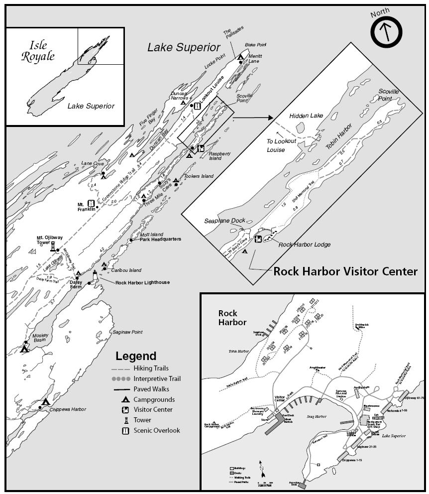
    Topographic Map of Rock Harbor – Isle Royale National Park, Michigan

    January 3, 2010 /

    Isle Royale National Park

    Topographic map downloads from the USGS Store

    Map of Isle Royale National Park (PDF file)

    Rock Harbor area map

    Blog entries for Isle Royale National Park

    Weather forecast for Copper Harbor, Michigan vicinity

    Videos of other parks, A-Z List , Locator Map

    Share on FacebookShare on Facebook

    read more
    Traveler John 0 Comments
  • Campsites,  Other Sites,  Walk-In Sites,  Water Access

    Rock Harbor Campsite Shelter – Isle Royale National Park, Michigan

    January 3, 2010 /


    ©2009 John Wanserski for Creative Juice LLC
    Isle Royale National Park

    Camping in Isle Royale National Park

    Map of Isle Royale National Park (PDF file)

    Rock Harbor area map

    Weather forecast for Rock Harbor, Isle Royale vicinity

    Blog entries for Isle Royale National Park

    Weather forecast for Copper Harbor, Michigan vicinity

    Videos of other parks, A-Z List , Locator Map

    Share on FacebookShare on Facebook

    read more
    Traveler John 0 Comments
  • Campgrounds,  Nat. Park/Forests,  Videos

    Video of Signal Mountain Campground, Grand Tetons National Park – Wyoming

    August 6, 2009 /

    The Tetons first received government protection in 1897 when Congress created the Teton Forest Reserve. In 1929, the central peaks of the Teton Range and a half dozen lakes at their base officially became Grand Teton National Park. In the mid-1930s John D. Rockefeller, Jr. bought 35,000 acres of property next to the park. In 1943 the Jackson Hole National Monument was created with a 221,000 acre tract of valley lands around the Snake River. By 1950 the original 1929 park was united with the 1943 Jackson Hole National Monument to create the present day 485 square mile park. The Tetons, rising abruptly from the floor of the Snake River Valley, are fault block mountains with their origin about 13 million years ago. Elk and pronghorn antelope make annual migrations through the park. Moose are seen around the Snake River wetlands and mountain lakes. Black bear and grizzlies roam the mountain slopes and wooded lake shores. The park has five campgrounds with 200 miles of trails to explore. The Colter Bay Visitor Center houses an Indian Arts Museum. Music copyright 2008 by Maury Smith. Slideshow and photographs copyright 2008, Creative Juice LLC.

    Grand Tetons National Park

    Campgrounds in Grand Tetons National Park

    Grand Tetons National Park blog postings

    Videos of other parks, A-Z List , Locator Map

    Share on FacebookShare on Facebook

    read more
    Traveler John 0 Comments
  • Campgrounds,  Nat. Park/Forests,  Videos

    Video of the Many Glacier Campground, Glacier National Park

    July 23, 2009 /

    With over 700 miles of trails, Glacier is a hikers paradise for adventurous visitors seeking wilderness and solitude. This entire area holds great spiritual importance to the Blackfeet, Salish, and Kootenai people. The Blackfeet Indians controlled the vast prairies east of the mountains. The Salish and Kootenai Indians lived and hunted in the western valleys. In 1806, the Lewis and Clark Expedition came within 50 miles of the area that is now the park. George Bird Grinnell was an early explorer to this part of Montana and spent many years working to get the park established. The area was made a Forest Preserve in 1900. President Taft, in 1910, signed the bill establishing Glacier as the countrys 10th national park. The final section of the Going-to-the-Sun Road, over Logan Pass, was completed in 1932 after 11 years of work. The road, a National Historic Landmark, is one of the most scenic roads in North America. Miles of hiking trails follow routes first used by trappers in the early 1800s. Several hotels and chalets, built by the Great Northern Railway in the early 1900s, offer lodging for summer guests to the park. Music by Maury Smith, copyright 2008. Slideshow and photographs copyright 2008 by Creative Juice LLC.

    Glacier National Park

    Many Glacier campground

    Blog entries for Glacier National Park, MT

    Weather forecast for the East Glacier Park, Montana vicinity

    Videos of other parks, A-Z List , Locator Map

    Share on FacebookShare on Facebook

    read more
    Traveler John 0 Comments
  • Nat. Park/Forest,  Picture of the Day

    Bear near Many Glacier Hotel – Glacier National Park, Montana

    April 11, 2009 /

    Glacier National Park

    Many Glacier campground

    Redrock Falls video, Many Glacier area

    Blog entries for Glacier National Park, MT

    Weather forecast for the East Glacier Park, Montana vicinity

    Videos of other parks, A-Z List , Locator Map

    Share on FacebookShare on Facebook

    read more
    Traveler John 0 Comments
  • Nat. Park/Forest,  Picture of the Day

    The Three Gossips – Arches National Park, Utah

    April 9, 2009 /

    Arches National Park

    Desert Solitaire: a Season in the Wilderness by Edward Abbey

    National Park Service maps

    Weather forecast for Arches National Park vicinity

    Blog entries for Arches National Park

    Videos of other parks, A-Z List , Locator Map

    Share on FacebookShare on Facebook

    read more
    Traveler John 0 Comments
  • Nat. Park/Forest,  Picture of the Day

    Skyline Arch – Arches National Park, Utah

    April 8, 2009 /

    Arches National Park

    The Essential Arches by the National Park Traveler

    National Park Service maps

    Weather forecast for Arches National Park vicinity

    Blog entries for Arches National Park

    Videos of other parks, A-Z List , Locator Map

    Share on FacebookShare on Facebook

    read more
    Traveler John 0 Comments
 Older Posts
Newer Posts 

Random Entry

Evening Twilight, Flint Hills on I-35 Between Emporia and Witchita - Kansas

Created By Bunk Beds

Purchase Prints of My Sacred Spaces

Art Prints

Wisconsin Books

Categories

  • Ancient Peoples (292)
    • Cliff Dwellings (141)
    • Mound Builders (36)
  • Books (16)
  • Campsites (176)
    • .Wisconsin Sites (135)
    • Other Sites (41)
    • Walk-In Sites (29)
    • Water Access (40)
  • Coffee Houses (824)
    • Madison Coffee (167)
    • Other Coffee (277)
    • WI Coffee (547)
  • Maps (174)
    • Other Maps (49)
    • WI Maps (125)
  • Picture of the Day (6,190)
    • Kaleidoscope (205)
    • Kayak Waters (1,140)
    • Nat. Park/Forest (1,389)
    • Other Countries (33)
    • Other States (3,005)
    • Wisconsin (2,909)
  • Videos (150)
    • Campgrounds (92)
    • County Parks (6)
    • Nat. Park/Forests (28)
    • Other Places (7)
    • State Forest (27)
    • State Park (81)
    • Trails (20)

+ WI Earth Links

  • – WI State Parks
  • Aldo Leopold Foundation
  • Aldo Leopold Legacy Trails
  • Apostle Islands
  • BirdCast
  • Botanical Club of WI
  • Chequamegon-Nicolet
  • Creative Juice LLC
  • Daycreek.com
  • Discover Wisconsin
  • Door County Land Trust
  • Earth Spaces – YouTube
  • Earthspace Twitter
  • Fishing Forecast
  • Friends of WI State Parks
  • Gathering Waters
  • Gaylord Nelson Wilderness
  • Glacial Lakes Conservancy
  • GLIFWC
  • Great Lakes Forever
  • Great Lakes Maps
  • Great Lakes Nautical Charts
  • Great Lakes Waterfalls
  • Ice Age Trail
  • Ice Age Trail Alliance
  • Kickapoo Valley Preserve
  • Lake Michigan Water Trail
  • Lakeland Aerial Photo
  • Lower WI Riverway
  • Mississippi River Charts
  • Mississippi River Trail
  • Native Am. Tourism of WI
  • Natural Heritage Land Trust
  • Nelson Institute
  • Olbrich Botanical Gardens
  • Prairie Enthusiasts
  • River Alliance of WI
  • Sigurd Olson Environ. Inst.
  • St. Croix Scenic Riverway
  • Teardrop Campers
  • The High Ground
  • Travel Green Wisconsin
  • Travel Wisconsin.com
  • Trees of Wisconsin
  • Troy Gardens
  • UW Arboretum
  • UW Press
  • UW Press WI Books
  • UW Sea Grant Institute
  • Wendt Library
  • WGNHS
  • WI Academy
  • WI Beach Health
  • WI Bear
  • WI Bike Trails
  • WI Bird Conservation
  • WI Birding & Nature Trails
  • WI Blue Book
  • WI Campion Trees
  • WI Canoe Heritage Museum
  • WI Coastal Atlas
  • WI Cougar Sightings
  • WI County Forests
  • WI County Parks
  • WI Covered Bridges
  • WI Dark Sky Sites
  • WI DNR Maps
  • WI Elk Herd
  • WI Endangered Resources
  • WI Fall Color Report
  • WI Fishing
  • WI Geography & Climate
  • WI Historic Sites
  • WI Historical Markers
  • WI HomeTownLocator
  • WI Horse Trails
  • WI Indian Mounds
  • WI Lake Maps
  • WI Land Trusts
  • WI Magazine of History
  • WI Maritime Trails
  • WI Minerals Database
  • WI Museums
  • WI Nat. Hist. Landmarks
  • WI Nat. Natural Landmarks
  • WI Nat. Res. Foundation
  • WI Nat. Wildlife Refuges
  • WI Natural Areas
  • WI Natural Resources Mag
  • WI Nature Conservancy
  • WI North Country Trail
  • WI Record Fish
  • WI Recreation Trails
  • WI Rustic Roads
  • WI Scenic Byways
  • WI Shipwrecks
  • WI Snow Report
  • WI State Cartographer
  • WI State Climatology Office
  • WI State Herbarium
  • WI State Historical Society
  • WI State Wildlife Areas
  • WI Statistics
  • WI Turkeys
  • WI Water
  • WI Water Trails
  • WI Weather
  • WI Wetlands Association
  • WI Wilderness
  • WI Wolves
  • WisconsinView
  • WOJB Radio

~ Earth Links

  • America's Quietist Routes
  • Backroads
  • Ctr for Sustainable Destinations
  • Daycreek.com
  • Earth Porn
  • Earthspace Twitter
  • Fishing Forecast
  • Google NGram Viewer
  • Historical Marker Database
  • iLike
  • Intern’l Dark Sky Assn.
  • LandScope America
  • Live Music Archive
  • Mississippi River Trail
  • NASA Earth Observatory
  • Nat. Hist. Landmarks
  • Nat. Register of Hist. Places
  • National Geographic Soc.
  • National Map
  • National Park Maps
  • National Park Service
  • National Parks (PBS TV)
  • National Parks Traveler
  • National Recreation Trails
  • National Scenic Byways
  • National Trails System
  • Native Tourism
  • Nature Conservancy
  • NatureServe
  • Nelson Institute
  • North Country Trail
  • Photosynth
  • Picture Gallery
  • Ramsar List of Wetlands
  • S. Arizona Nonprofits
  • Search-Cube
  • Shades of Rez
  • Shelfari
  • SoundCloud
  • TouchGraph
  • TrailLink
  • Treehugger
  • U.S. Forest Service
  • US Home Town Locator
  • USGS Store
  • Weather Channel
  • Wilderness Institute
  • Wilderness Volunteers
  • WiserEarth

Tags

Animals Architecture Arizona Art Beach California Canyon Capital Springs Chippewa County Chippewa Moraine Clouds Coffee House County Park Creek Dane County Park Desert Evening Twilight Hiking Trail Inside Seating Kaleidoscope Lake Madison WI Morning Twilight Mountains Museum National Forest National Monument National Park New Mexico River Sculpture Service Counter Shore Sonoran Desert State Forest State Recreation Area Stream Texas Trees Twilight Utah Vermont Wildflowers Wildlife Wisconsin Coffee House

Archives

Ashe Theme by WP Royal.