My Wisconsin Space

Wisconsin Campgrounds, Wisconsin State Parks, National Parks and Monuments, Sacred Spaces

  • Home
  • A-Z List
  • Coffee Houses
  • Park & Campsite Videos
  • About
  • Home
  • A-Z List
  • Coffee Houses
  • Park & Campsite Videos
  • About

No Widgets found in the Sidebar Alt!

  • Maps,  Other Maps

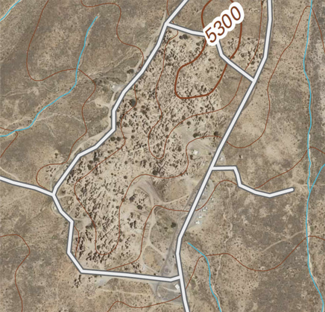
    Orthoimage Map of City of Rocks State Park – Faywood, New Mexico

    June 13, 2013 /

    Orthoimage Map of City of Rocks State Park - Faywood, New Mexico

    City of Rocks State Park

    Map of City of Rocks State Park (PDF File)

    US Topo, the next generation of digital topographic maps from the USGS

    Definition of orthoimage (Wikipedia entry)

    USGS Store for downloading free topographic maps

    Weather forecast for Faywood, New Mexico

    Blog entries for City of Rocks State Park

    Videos of other parks, A-Z List , Locator Map

    Share on FacebookShare on Facebook

    read more
    Traveler John 0 Comments
  • Maps,  Other Maps

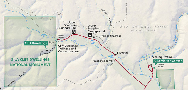
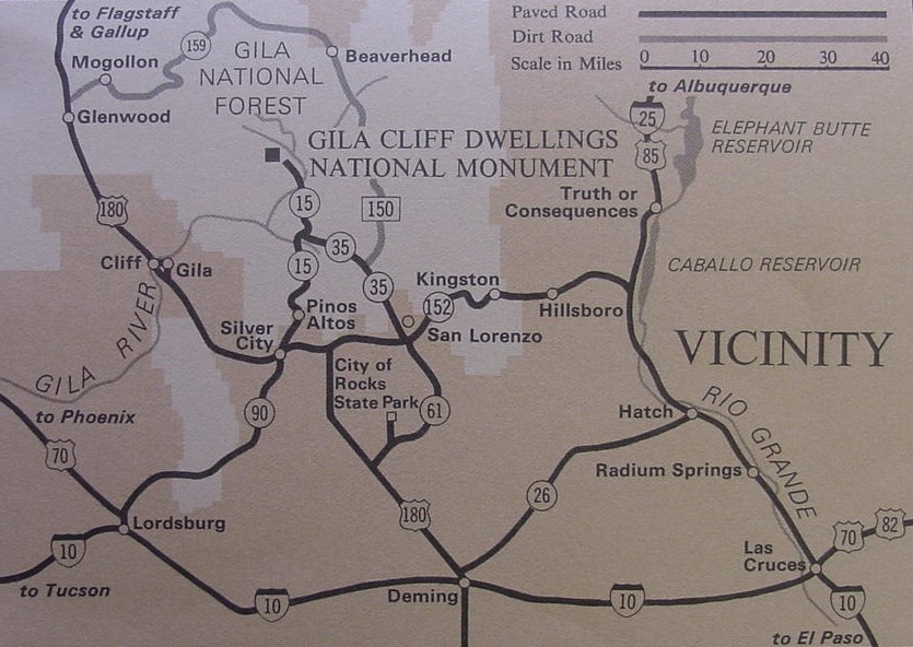
    Map of Gila Cliff Dwellings National Monument and Campgrounds – Silver City, New Mexico

    May 9, 2013 /

    Map of Gila Cliff Dwellings National Monument and Campgrounds - Silver City, New Mexico

    Gila Cliff Dwellings National Monument

    Map of Gila Cliff Dwellings National Monument

    Gila Cliff Dwellings National Monument area map

    Blog entries for Gila Cliff Dwellings National Monument

    Weather forecast for Silver City, NM vicinity

    Videos of other parks, A-Z List , Locator Map

    Share on FacebookShare on Facebook

    read more
    Traveler John 0 Comments
  • Maps,  Nat. Park/Forest,  Other Maps

    Map of Organ Pipe Cactus National Monument

    April 16, 2013 /

    Map of Organ Pipe Cactus National Monument - Ajo, Arizona
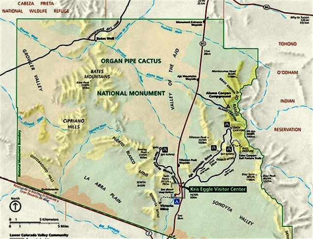
    ©2013 John Wanserski for Creative Juice LLC

    Organ Pipe Cactus National Monument

    Map of Organ Pipe Cactus National Monument (PDF file)

    Planning your visit brochure (PDF file)

    Blog entries for Organ Pipe Cactus National Monument

    Weather forecast for Ajo, Arizona vicinity

    Videos of other parks, A-Z List , Locator Map

    Share on FacebookShare on Facebook

    read more
    Traveler John 0 Comments
  • Maps,  WI Maps

    Nautical Chart of Apostle Islands – Bayfield County, Wisconsin

    December 2, 2012 /


    (Frog Bay is to the left of Oak Island near the center of the photograph)

    NOAA Office of Coast Survey Nautical Chart for the Apostle Islands

    Nautical Chart Online Viewer for the Great Lakes

    Frog Bay Tribal National Park

    Weather forecast for Red Cliff, WI vicinity

    Blog entries for Frog Bay Tribal National Park

    Videos of other parks, A-Z List , Locator Map

    Share on FacebookShare on Facebook

    read more
    Traveler John 0 Comments
  • Maps,  WI Maps

    Topographic Map of Houghton Falls Nature Perserve and Vicinity- Washburn, Wisonsin

    November 16, 2012 /

    Houghton Falls Nature Preserve

    Bayfield Regional Conservancy

    Blog entries for Houghton Falls Trail

    USGS Store for downloading free topographic maps

    DNR Maps and Aerial Photos

    Weather forecast for Washburn, Wisconsin vicinity

    Videos of other parks, A-Z List , Locator Map

    Share on FacebookShare on Facebook

    read more
    Traveler John 0 Comments
  • Maps,  WI Maps

    Map of Wisconsin Iron Ore Resources (1976)

    October 2, 2012 /

    Iron Mining in Wisconsin

    Wisconsin Geological and Natural History Survey

    Publications and Maps at the Wisconsin Geological and Natural History Survey

    Wisconsin maps at the Wisconsin State Cartographer’s site

    USGS Store for topographic maps and other maps

    Blog entries for Wisconsin maps

    Videos of other parks, A-Z List , Locator Map

    Share on FacebookShare on Facebook

    read more
    Traveler John 0 Comments
  • Maps,  WI Maps

    Map, Colton’s Wisconsin 1859 (Wisconsin State Historical Society)

    September 16, 2012 /


    (“Any map may be printed or downloaded at no cost for nonprofit educational use by teachers and students, or for private use by individual researchers. Nothing may be reproduced in any format for commercial purposes without prior permission from the Wisconsin Historical Society.”)

    Map of Colton’s Wisconsin 1859 (Wisconsin State Historical Society)

    Wisconsin Historical Society

    Wisconsin Historical Society, Map and Atlas Collection

    Wisconsin maps at the Wisconsin State Cartographer’s site

    USGS Store for topographic maps and other maps

    Blog entries for Wisconsin maps

    Videos of other parks, A-Z List , Locator Map

    Share on FacebookShare on Facebook

    read more
    Traveler John 0 Comments
  • Maps,  WI Maps

    Wisconsin’s Average Monthly Temperatures for August

    August 11, 2012 /

    Wisconsin’s Summer Climate

    U.S. Drought Monitor

    Wisconsin Geological and Natural History Survey

    Publications and Maps at the Wisconsin Geological and Natural History Survey

    Wisconsin maps at the Wisconsin State Cartographer’s site

    USGS Store for topographic maps and other maps

    Blog entries for Wisconsin maps

    Videos of other parks, A-Z List , Locator Map

    Share on FacebookShare on Facebook

    read more
    Traveler John 0 Comments
 Older Posts

Random Entry

Front Entrance, Decibel Coffee Works - Tucson, AZ

Created By Bunk Beds

Purchase Prints of My Sacred Spaces

Art Prints

Wisconsin Books

Categories

  • Ancient Peoples (292)
    • Cliff Dwellings (141)
    • Mound Builders (36)
  • Books (16)
  • Campsites (176)
    • .Wisconsin Sites (135)
    • Other Sites (41)
    • Walk-In Sites (29)
    • Water Access (40)
  • Coffee Houses (699)
    • Madison Coffee (135)
    • Other Coffee (228)
    • WI Coffee (471)
  • Maps (174)
    • Other Maps (49)
    • WI Maps (125)
  • Picture of the Day (5,877)
    • Kaleidoscope (205)
    • Kayak Waters (1,129)
    • Nat. Park/Forest (1,338)
    • Other States (2,892)
    • Wisconsin (2,808)
  • Videos (150)
    • Campgrounds (92)
    • County Parks (6)
    • Nat. Park/Forests (28)
    • Other Places (7)
    • State Forest (27)
    • State Park (81)
    • Trails (20)

+ WI Earth Links

  • – WI State Parks
  • Aldo Leopold Foundation
  • Aldo Leopold Legacy Trails
  • Apostle Islands
  • BirdCast
  • Botanical Club of WI
  • Chequamegon-Nicolet
  • Creative Juice LLC
  • Daycreek.com
  • Discover Wisconsin
  • Door County Land Trust
  • Earth Spaces – YouTube
  • Earthspace Twitter
  • Fishing Forecast
  • Friends of WI State Parks
  • Gathering Waters
  • Gaylord Nelson Wilderness
  • Glacial Lakes Conservancy
  • GLIFWC
  • Great Lakes Forever
  • Great Lakes Maps
  • Great Lakes Nautical Charts
  • Great Lakes Waterfalls
  • Ice Age Trail
  • Ice Age Trail Alliance
  • Kickapoo Valley Preserve
  • Lake Michigan Water Trail
  • Lakeland Aerial Photo
  • Lower WI Riverway
  • Mississippi River Charts
  • Mississippi River Trail
  • Native Am. Tourism of WI
  • Natural Heritage Land Trust
  • Nelson Institute
  • Olbrich Botanical Gardens
  • Prairie Enthusiasts
  • River Alliance of WI
  • Sigurd Olson Environ. Inst.
  • St. Croix Scenic Riverway
  • Teardrop Campers
  • The High Ground
  • Travel Green Wisconsin
  • Travel Wisconsin.com
  • Trees of Wisconsin
  • Troy Gardens
  • UW Arboretum
  • UW Press
  • UW Press WI Books
  • UW Sea Grant Institute
  • Wendt Library
  • WGNHS
  • WI Academy
  • WI Beach Health
  • WI Bear
  • WI Bike Trails
  • WI Bird Conservation
  • WI Birding & Nature Trails
  • WI Blue Book
  • WI Campion Trees
  • WI Canoe Heritage Museum
  • WI Coastal Atlas
  • WI Cougar Sightings
  • WI County Forests
  • WI County Parks
  • WI Covered Bridges
  • WI Dark Sky Sites
  • WI DNR Maps
  • WI Elk Herd
  • WI Endangered Resources
  • WI Fall Color Report
  • WI Fishing
  • WI Geography & Climate
  • WI Historic Sites
  • WI Historical Markers
  • WI HomeTownLocator
  • WI Horse Trails
  • WI Indian Mounds
  • WI Lake Maps
  • WI Land Trusts
  • WI Magazine of History
  • WI Maritime Trails
  • WI Minerals Database
  • WI Museums
  • WI Nat. Hist. Landmarks
  • WI Nat. Natural Landmarks
  • WI Nat. Res. Foundation
  • WI Nat. Wildlife Refuges
  • WI Natural Areas
  • WI Natural Resources Mag
  • WI Nature Conservancy
  • WI North Country Trail
  • WI Record Fish
  • WI Recreation Trails
  • WI Rustic Roads
  • WI Scenic Byways
  • WI Shipwrecks
  • WI Snow Report
  • WI State Cartographer
  • WI State Climatology Office
  • WI State Herbarium
  • WI State Historical Society
  • WI State Wildlife Areas
  • WI Statistics
  • WI Turkeys
  • WI Water
  • WI Water Trails
  • WI Weather
  • WI Wetlands Association
  • WI Wilderness
  • WI Wolves
  • WisconsinView
  • WOJB Radio

~ Earth Links

  • America's Quietist Routes
  • Backroads
  • Ctr for Sustainable Destinations
  • Daycreek.com
  • Earth Porn
  • Earthspace Twitter
  • Fishing Forecast
  • Google NGram Viewer
  • Historical Marker Database
  • iLike
  • Intern’l Dark Sky Assn.
  • LandScope America
  • Live Music Archive
  • Mississippi River Trail
  • NASA Earth Observatory
  • Nat. Hist. Landmarks
  • Nat. Register of Hist. Places
  • National Geographic Soc.
  • National Map
  • National Park Maps
  • National Park Service
  • National Parks (PBS TV)
  • National Parks Traveler
  • National Recreation Trails
  • National Scenic Byways
  • National Trails System
  • Native Tourism
  • Nature Conservancy
  • NatureServe
  • Nelson Institute
  • North Country Trail
  • Photosynth
  • Picture Gallery
  • Ramsar List of Wetlands
  • S. Arizona Nonprofits
  • Search-Cube
  • Shades of Rez
  • Shelfari
  • SoundCloud
  • TouchGraph
  • TrailLink
  • Treehugger
  • U.S. Forest Service
  • US Home Town Locator
  • USGS Store
  • Weather Channel
  • Wilderness Institute
  • Wilderness Volunteers
  • WiserEarth

Tags

Animals Architecture Arizona Art Beach campsite Canyon Capital Springs Chippewa County Chippewa Moraine Clouds Coffee House County Park Creek Dane County Park Desert Evening Twilight Hiking Trail Inside Seating Kaleidoscope Lake Madison WI map Morning Twilight Mountains National Forest National Monument National Park New Mexico River Shore Sonoran Desert State Forest State Recreation Area Stream Sunset Texas Trees Twilight Utah Vermont Waterfalls Wildflowers Wildlife Wisconsin Coffee House

Archives

Ashe Theme by WP Royal.