-
Island in Otter Lake, Otter Lake County Park – Stanley, Wisconsin
-
Goose Island Park – La Crosse County, Wisconsin
©2010 John Wanserski for Creative Juice LLCGoose Island Trail Map and Brochure (PDF file)
Goose Island Park blog postings
Weather forecast for La Crosse, Wisconsin vicinity
-
Goose Island Navigation Chart – La Crosse County, Wisconsin
-
Goose Island Park – La Crosse County, Wisconsin
©2010 John Wanserski for Creative Juice LLCGoose Island Trail Map and Brochure (PDF file)
Goose Island Park blog postings
Weather forecast for La Crosse, Wisconsin vicinity
-
Eagle Island, Apostle Islands National Lakeshore – Bayfield, Wisconsin
©2010 John Wanserski for Creative Juice LLC
Gull and Eagle Islands combined have 88% of the lakeshore’s breeding herring gull populations and 80% of the herring gull breeding population on the entire Wisconsin shore of Lake Superior. Eagle Island has the only great blue heron rookery in the park.Apostle Islands National Lakeshore
Hiking in the Apostle Islands National Lakeshore
Apostle Islands National Lakeshore (Wikipedia entry)
Apostle Islands National Lakeshore blog postings
Weather forecast for Bayfield, Wisconsin vicinity
-
View from Scoville Trail – Isle Royale National Park, Michigan
©2009 John Wanserski for Creative Juice LLC
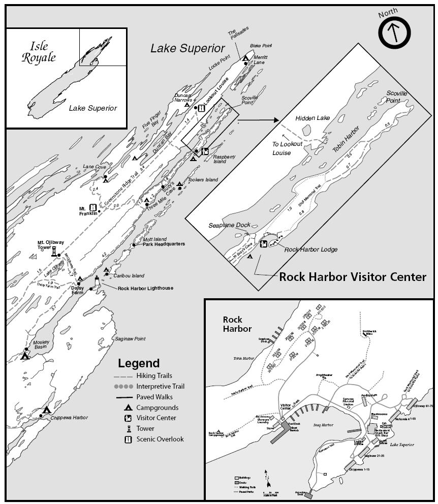
Isle Royale National ParkMap of Isle Royale National Park (PDF file)
Rock Harbor area guide (see trails on page 2)
Blog entries for Isle Royale National Park
Weather forecast for Copper Harbor, Michigan vicinity
-
Duncan Bay – Isle Royale National Park, Michigan
©2009 John Wanserski for Creative Juice LLC
Isle Royale National ParkMap of Isle Royale National Park (PDF file)
Blog entries for Isle Royale National Park
Weather forecast for Copper Harbor, Michigan vicinity
-
Topographic Map of Rock Harbor – Isle Royale National Park, Michigan
