My Wisconsin Space

Wisconsin Campgrounds, Wisconsin State Parks, National Parks and Monuments, Sacred Spaces

  • Home
  • A-Z List
  • Coffee Houses
  • Park & Campsite Videos
  • About
  • Home
  • A-Z List
  • Coffee Houses
  • Park & Campsite Videos
  • About

No Widgets found in the Sidebar Alt!

  • Kayak Waters,  Picture of the Day,  Wisconsin

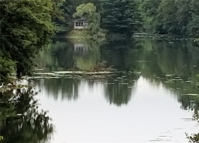
    Glen Loc Flowage and Cottage – Chippewa Falls, Wisconsin

    October 6, 2017 /


    ©2017 John Wanserski for Creative Juice LLC

    Glen Loch Flowage

    City of Chippewa Falls

    Chippewa Falls parks, recreation and forestry

    Chippewa County Recreation

    Chippewa Falls, Wisconsin (Wikipedia entry)

    Blog entries for Irvine Park, Chippewa Falls

    Weather forecast for Chippewa Falls, Wisconsin vicinity

    Videos of other parks, A-Z List , Locator Map

    Share on FacebookShare on Facebook

    read more
    Traveler John 0 Comments
  • Kayak Waters,  Picture of the Day,  Wisconsin

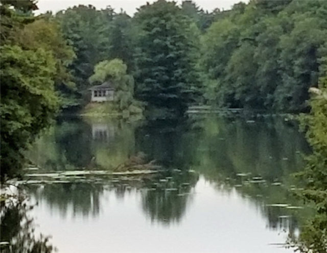
    Cottage on Island in Glen Loc Flowage – Chippewa Falls, Wisconsin

    October 5, 2017 /


    ©2017 John Wanserski for Creative Juice LLC

    Glen Loch Flowage

    City of Chippewa Falls

    Chippewa Falls parks, recreation and forestry

    Chippewa County Recreation

    Chippewa Falls, Wisconsin (Wikipedia entry)

    Blog entries for Irvine Park, Chippewa Falls

    Weather forecast for Chippewa Falls, Wisconsin vicinity

    Videos of other parks, A-Z List , Locator Map

    Share on FacebookShare on Facebook

    read more
    Traveler John 0 Comments
  • Kayak Waters,  Picture of the Day,  Wisconsin

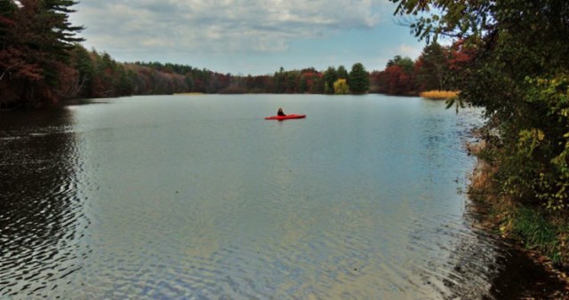
    Kayaker on Glen Loch Flowage – Chippewa Falls, Wisconsin

    November 3, 2014 /

    Keyaker in Glen Loch
    ©2014 John Wanserski for Creative Juice LLC

    Glen Loch Flowage

    City of Chippewa Falls

    Chippewa Falls parks, recreation and forestry

    Chippewa County Recreation

    Chippewa Falls, Wisconsin (Wikipedia entry)

    Blog entries for Irvine Park, Chippewa Falls

    Weather forecast for Chippewa Falls, Wisconsin vicinity

    Videos of other parks, A-Z List , Locator Map

    Share on FacebookShare on Facebook

    read more
    Traveler John 0 Comments
  • Kayak Waters,  Picture of the Day,  Wisconsin

    Sunrise over Old Abe Lake – Chippewa County, Wisconsin

    October 23, 2010 /


    ©2010 John Wanserski for Creative Juice LLC

    Chippewa River (Wikipedia entry)

    Old Abe Lake (PDF File)

    Chippewa County, Wisconsin

    Chippewa County Park System

    Old Abe State Trail

    Wisconsin Scenic Byways

    Blog entries for Chippewa County

    Weather forecast for Jim Falls, Wisconsin vicinity

    Videos of other parks, A-Z List , Locator Map

    Share on FacebookShare on Facebook

    read more
    Traveler John 0 Comments
  • Kayak Waters,  Picture of the Day,  Wisconsin

    Turtle-Flambeau Flowage Scenic Waters Area – Mercer, Wisconsin

    July 26, 2009 /


    ©2009 John Wanserski for Creative Juice LLC
    Turtle-Flambeau Scenic Waters Area

    Map of Turtle-Flambeau Scenic Waters Area

    Quiet area in the Turtle-Flambeau Scenic Waters Area

    Blog entries for the Turtle-Flambeau Scenic Waters Area

    IPod videos of other parks, A-Z List , Locator Map

    Share on FacebookShare on Facebook

    read more
    Traveler John 0 Comments
  • Kayak Waters,  Maps,  WI Maps

    Topographic Map of Murray’s Landing Area, Turtle-Flambeau Flowage Scenic Waters Area – Mercer, Wisconsin

    July 26, 2009 /

    Turtle-Flambeau Scenic Waters Area

    Map of Turtle-Flambeau Scenic Waters Area

    Wisconsin Boat and Developed Shore Fishing Access

    USGS Store (topographic maps for downloading)

    Blog entries for the Turtle-Flambeau Scenic Waters Area

    IPod videos of other parks, A-Z List , Locator Map

    Share on FacebookShare on Facebook

    read more
    Traveler John 0 Comments
  • Kayak Waters,  Picture of the Day,  Wisconsin

    Turtle-Flambeau Flowage Scenic Waters Area – Mercer, Wisconsin

    July 25, 2009 /


    ©2009 John Wanserski for Creative Juice LLC
    Turtle-Flambeau Scenic Waters Area

    Map of Turtle-Flambeau Scenic Waters Area

    Boating/Paddling in the Turtle-Flambeau Scenic Waters Area

    Water levels on the Turtle-Flambeau Scenic Waters Area

    Blog entries for the Turtle-Flambeau Scenic Waters Area

    IPod videos of other parks, A-Z List , Locator Map

    Share on FacebookShare on Facebook

    read more
    Traveler John 0 Comments
  • .Wisconsin Sites,  Campsites,  Kayak Waters,  Water Access

    Turtle-Flambeau Flowage Scenic Waters Area, Campsite D9 – Mercer, Wisconsin

    July 25, 2009 /


    ©2009 John Wanserski for Creative Juice LLC
    Turtle-Flambeau Scenic Waters Area

    Map of Turtle-Flambeau Scenic Waters Area

    Camping in the Turtle-Flambeau Scenic Waters Area

    Blog entries for the Turtle-Flambeau Scenic Waters Area

    IPod videos of other parks, A-Z List , Locator Map

    Share on FacebookShare on Facebook

    read more
    Traveler John 0 Comments
 Older Posts

Random Entry

Mail delivery failed: returning message to sender

Created By Bunk Beds

Purchase Prints of My Sacred Spaces

Art Prints

Wisconsin Books

Categories

  • Ancient Peoples (292)
    • Cliff Dwellings (141)
    • Mound Builders (36)
  • Books (16)
  • Campsites (176)
    • .Wisconsin Sites (135)
    • Other Sites (41)
    • Walk-In Sites (29)
    • Water Access (40)
  • Coffee Houses (699)
    • Madison Coffee (135)
    • Other Coffee (228)
    • WI Coffee (471)
  • Maps (174)
    • Other Maps (49)
    • WI Maps (125)
  • Picture of the Day (5,878)
    • Kaleidoscope (205)
    • Kayak Waters (1,129)
    • Nat. Park/Forest (1,338)
    • Other States (2,893)
    • Wisconsin (2,808)
  • Videos (150)
    • Campgrounds (92)
    • County Parks (6)
    • Nat. Park/Forests (28)
    • Other Places (7)
    • State Forest (27)
    • State Park (81)
    • Trails (20)

+ WI Earth Links

  • – WI State Parks
  • Aldo Leopold Foundation
  • Aldo Leopold Legacy Trails
  • Apostle Islands
  • BirdCast
  • Botanical Club of WI
  • Chequamegon-Nicolet
  • Creative Juice LLC
  • Daycreek.com
  • Discover Wisconsin
  • Door County Land Trust
  • Earth Spaces – YouTube
  • Earthspace Twitter
  • Fishing Forecast
  • Friends of WI State Parks
  • Gathering Waters
  • Gaylord Nelson Wilderness
  • Glacial Lakes Conservancy
  • GLIFWC
  • Great Lakes Forever
  • Great Lakes Maps
  • Great Lakes Nautical Charts
  • Great Lakes Waterfalls
  • Ice Age Trail
  • Ice Age Trail Alliance
  • Kickapoo Valley Preserve
  • Lake Michigan Water Trail
  • Lakeland Aerial Photo
  • Lower WI Riverway
  • Mississippi River Charts
  • Mississippi River Trail
  • Native Am. Tourism of WI
  • Natural Heritage Land Trust
  • Nelson Institute
  • Olbrich Botanical Gardens
  • Prairie Enthusiasts
  • River Alliance of WI
  • Sigurd Olson Environ. Inst.
  • St. Croix Scenic Riverway
  • Teardrop Campers
  • The High Ground
  • Travel Green Wisconsin
  • Travel Wisconsin.com
  • Trees of Wisconsin
  • Troy Gardens
  • UW Arboretum
  • UW Press
  • UW Press WI Books
  • UW Sea Grant Institute
  • Wendt Library
  • WGNHS
  • WI Academy
  • WI Beach Health
  • WI Bear
  • WI Bike Trails
  • WI Bird Conservation
  • WI Birding & Nature Trails
  • WI Blue Book
  • WI Campion Trees
  • WI Canoe Heritage Museum
  • WI Coastal Atlas
  • WI Cougar Sightings
  • WI County Forests
  • WI County Parks
  • WI Covered Bridges
  • WI Dark Sky Sites
  • WI DNR Maps
  • WI Elk Herd
  • WI Endangered Resources
  • WI Fall Color Report
  • WI Fishing
  • WI Geography & Climate
  • WI Historic Sites
  • WI Historical Markers
  • WI HomeTownLocator
  • WI Horse Trails
  • WI Indian Mounds
  • WI Lake Maps
  • WI Land Trusts
  • WI Magazine of History
  • WI Maritime Trails
  • WI Minerals Database
  • WI Museums
  • WI Nat. Hist. Landmarks
  • WI Nat. Natural Landmarks
  • WI Nat. Res. Foundation
  • WI Nat. Wildlife Refuges
  • WI Natural Areas
  • WI Natural Resources Mag
  • WI Nature Conservancy
  • WI North Country Trail
  • WI Record Fish
  • WI Recreation Trails
  • WI Rustic Roads
  • WI Scenic Byways
  • WI Shipwrecks
  • WI Snow Report
  • WI State Cartographer
  • WI State Climatology Office
  • WI State Herbarium
  • WI State Historical Society
  • WI State Wildlife Areas
  • WI Statistics
  • WI Turkeys
  • WI Water
  • WI Water Trails
  • WI Weather
  • WI Wetlands Association
  • WI Wilderness
  • WI Wolves
  • WisconsinView
  • WOJB Radio

~ Earth Links

  • America's Quietist Routes
  • Backroads
  • Ctr for Sustainable Destinations
  • Daycreek.com
  • Earth Porn
  • Earthspace Twitter
  • Fishing Forecast
  • Google NGram Viewer
  • Historical Marker Database
  • iLike
  • Intern’l Dark Sky Assn.
  • LandScope America
  • Live Music Archive
  • Mississippi River Trail
  • NASA Earth Observatory
  • Nat. Hist. Landmarks
  • Nat. Register of Hist. Places
  • National Geographic Soc.
  • National Map
  • National Park Maps
  • National Park Service
  • National Parks (PBS TV)
  • National Parks Traveler
  • National Recreation Trails
  • National Scenic Byways
  • National Trails System
  • Native Tourism
  • Nature Conservancy
  • NatureServe
  • Nelson Institute
  • North Country Trail
  • Photosynth
  • Picture Gallery
  • Ramsar List of Wetlands
  • S. Arizona Nonprofits
  • Search-Cube
  • Shades of Rez
  • Shelfari
  • SoundCloud
  • TouchGraph
  • TrailLink
  • Treehugger
  • U.S. Forest Service
  • US Home Town Locator
  • USGS Store
  • Weather Channel
  • Wilderness Institute
  • Wilderness Volunteers
  • WiserEarth

Tags

Animals Architecture Arizona Art Beach campsite Canyon Capital Springs Chippewa County Chippewa Moraine Clouds Coffee House County Park Creek Dane County Park Desert Evening Twilight Hiking Trail Inside Seating Kaleidoscope Lake Madison WI map Morning Twilight Mountains National Forest National Monument National Park New Mexico River Shore Sonoran Desert State Forest State Recreation Area Stream Sunset Texas Trees Twilight Utah Vermont Waterfalls Wildflowers Wildlife Wisconsin Coffee House

Archives

Ashe Theme by WP Royal.