My Wisconsin Space

Wisconsin Campgrounds, Wisconsin State Parks, National Parks and Monuments, Sacred Spaces

  • Home
  • A-Z List
  • Coffee Houses
  • Park & Campsite Videos
  • About
  • Home
  • A-Z List
  • Coffee Houses
  • Park & Campsite Videos
  • About

No Widgets found in the Sidebar Alt!

  • Other States,  Picture of the Day

    Limestone Bluff, Pedernales Falls State Park – Johnson City, Texas

    December 19, 2014 /

    Limestone Bluff, Pedernales alls State Park
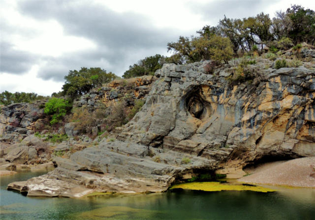
    ©2014 John Wanserski for Creative Juice LLC

    Pedernales Falls State Park

    Map of Pedernales Falls State Park (PDF File)

    Trails Map for Pedernales Falls State Park (PDF File)

    Geology of Pedernales Falls State Park and Enchanted Rock State Natural Area (PDF file)

    Weather forecast for Johnson City, Texas vicinity

    Blog entries for Pedernales Falls State Park

    Videos of other parks, A-Z List , Locator Map

    Share on FacebookShare on Facebook

    read more
    Traveler John 0 Comments
  • Picture of the Day,  Wisconsin

    Face of Roche A Cri, Roche A Cri State Part – Friendship, Wisconsin

    September 24, 2011 /


    ©2011 John Wanserski for Creative Juice LLC

    Roche A Cri State Park

    Carter Creek, Little Roche A Cri Watershed

    Map of Roche A Cri State Park

    History of Roche A Cri State Park

    Blog entries for Roche-A-Cri State Park

    Weather forecast for Friendship, Wisconsin vicinity

    Videos of other parks, A-Z List , Locator Map

    Share on FacebookShare on Facebook

    read more
    Traveler John 0 Comments
  • Picture of the Day,  Wisconsin

    Field of Lupines at Quincy Bluff and Wetlands State Natural Area – Adams County, Wisconsin

    June 8, 2011 /


    ©2011 John Wanserski for Creative Juice LLC

    Quincy Bluff and Wetlands State Natural Area

    Lupines (Wikipedia entry)

    Map of Quincy Bluff and Wetlands (PDF file)

    Map of State Natural Areas of Wisconsin

    Weather forecast for Mauston, Wisconsin vicinity

    Blog entries for Quincy Bluff and Wetlands State Natural Area

    Videos of other parks, A-Z List , Locator Map

    Share on FacebookShare on Facebook

    read more
    Traveler John 0 Comments
  • Picture of the Day,  Wisconsin

    Quincy Bluff, Quincy Bluff and Wetlands State Natural Area – Adams County, Wisconsin

    June 7, 2011 /


    ©2011 John Wanserski for Creative Juice LLC

    Quincy Bluff and Wetlands State Natural Area

    Map of Quincy Bluff and Wetlands (PDF file)

    Map of State Natural Areas of Wisconsin

    Weather forecast for Mauston, Wisconsin vicinity

    Blog entries for Quincy Bluff and Wetlands State Natural Area

    Videos of other parks, A-Z List , Locator Map

    Share on FacebookShare on Facebook

    read more
    Traveler John 0 Comments
  • .Wisconsin Sites,  Campsites

    Wisconsin Ridge Campsite 137, Wyalusing State Park – Bagley, Wisconsin

    November 7, 2010 /


    ©2010 John Wanserski for Creative Juice LLC

    Wyalusing State Park

    Maps of Wyalusing State Park

    Camping in Wyalusing State Park

    Blog entries for Wyalusing State Park

    Weather forecast for Bagley, Wisconsin vicinity

    Videos of other parks, A-Z List , Locator Map

    Share on FacebookShare on Facebook

    read more
    Traveler John 0 Comments
  • Other States,  Picture of the Day

    Illinois River from the Top of Starved Rock, Starved Rock State Park – Utica, Illinois

    January 10, 2010 /


    ©2009 John Wanserski for Creative Juice LLC
    Starved Rock State Park

    Trails of Starved Rock State Park

    Map of Starved Rock State Park (PDF file)

    Wikipedia entry for Starved Rock State Park

    Blog entries for Starved Rock State Park

    IPod videos of other parks, A-Z List , Locator Map

    Share on FacebookShare on Facebook

    read more
    Traveler John 0 Comments
  • Ancient Peoples,  Campgrounds,  State Park,  Videos

    Video of Roche-A-Cri State Park Campground – Friendship, Wisconsin

    May 23, 2009 /

    Roche-A-Cri (means shouting or whooping rock) or crevice in the rock as the French explorers called it, is a 300 foot sandstone bluff near Adams-Friendship, Wisconsin. The park, established in 1948, has viewable Native American petroglyphs and pictographs discovered in 1851, but were written a thousand years ago. Roche-A-Cri is made of Cambrian sandstone about 500,000 years old. It is a long narrow flat-topped ridge bordered by shear precipices. The bluff was once an island in the 1,800 square mile Glacial Lake Wisconsin. In 1994 a Wisconsin Conservation Corps group finished a 303 step stairway to the top of the bluff. The 605 acre park has a number of soft trails strewn with pine needles that are all linked to the 41 site shower-less campground. One leads to a prairie restoration project, crossing over a foot bridge on Carter Creek, a picturesque trout creek. All 41 campsites are included in this video. Music copyright 2008 by Maury Smith. Slideshow and photographs copyright 2008, Creative Juice LLC.

    Roche A Cri State Park

    Map of Roche A Cri State Park

    Camping at Roche A Cri State Park

    Blog entries for Roche-A-Cri State Park

    Weather forecast for Friendship, Wisconsin vicinity

    Videos of other parks, A-Z List , Locator Map

    Share on FacebookShare on Facebook

    read more
    Traveler John 0 Comments
  • Kayak Waters,  Picture of the Day,  Wisconsin

    Mississippi River from Buena Vista Park – Alma, Wisconsin

    May 12, 2009 /

    Alma, Wisconsin

    Upper Mississippi lock and dam 4 at Alma, Wisconsin

    Upper Mississippi River National Wildlife and Fish Refuge

    Great River Road, Wisconsin

    Blog entries for the Great River Road

    Weather forecast for Alma, Wisconsin vicinity

    Videos of other parks, A-Z List , Locator Map

    Share on FacebookShare on Facebook

    read more
    Traveler John 0 Comments
 Older Posts
Newer Posts 

Random Entry

Sunset Above Medano Creek, Great Sand Dunes National Park and Preserve - Mosca, CO

Created By Bunk Beds

Purchase Prints of My Sacred Spaces

Art Prints

Wisconsin Books

Categories

  • Ancient Peoples (292)
    • Cliff Dwellings (141)
    • Mound Builders (36)
  • Books (16)
  • Campsites (176)
    • .Wisconsin Sites (135)
    • Other Sites (41)
    • Walk-In Sites (29)
    • Water Access (40)
  • Coffee Houses (699)
    • Madison Coffee (135)
    • Other Coffee (228)
    • WI Coffee (471)
  • Maps (174)
    • Other Maps (49)
    • WI Maps (125)
  • Picture of the Day (5,878)
    • Kaleidoscope (205)
    • Kayak Waters (1,129)
    • Nat. Park/Forest (1,338)
    • Other States (2,893)
    • Wisconsin (2,808)
  • Videos (150)
    • Campgrounds (92)
    • County Parks (6)
    • Nat. Park/Forests (28)
    • Other Places (7)
    • State Forest (27)
    • State Park (81)
    • Trails (20)

+ WI Earth Links

  • – WI State Parks
  • Aldo Leopold Foundation
  • Aldo Leopold Legacy Trails
  • Apostle Islands
  • BirdCast
  • Botanical Club of WI
  • Chequamegon-Nicolet
  • Creative Juice LLC
  • Daycreek.com
  • Discover Wisconsin
  • Door County Land Trust
  • Earth Spaces – YouTube
  • Earthspace Twitter
  • Fishing Forecast
  • Friends of WI State Parks
  • Gathering Waters
  • Gaylord Nelson Wilderness
  • Glacial Lakes Conservancy
  • GLIFWC
  • Great Lakes Forever
  • Great Lakes Maps
  • Great Lakes Nautical Charts
  • Great Lakes Waterfalls
  • Ice Age Trail
  • Ice Age Trail Alliance
  • Kickapoo Valley Preserve
  • Lake Michigan Water Trail
  • Lakeland Aerial Photo
  • Lower WI Riverway
  • Mississippi River Charts
  • Mississippi River Trail
  • Native Am. Tourism of WI
  • Natural Heritage Land Trust
  • Nelson Institute
  • Olbrich Botanical Gardens
  • Prairie Enthusiasts
  • River Alliance of WI
  • Sigurd Olson Environ. Inst.
  • St. Croix Scenic Riverway
  • Teardrop Campers
  • The High Ground
  • Travel Green Wisconsin
  • Travel Wisconsin.com
  • Trees of Wisconsin
  • Troy Gardens
  • UW Arboretum
  • UW Press
  • UW Press WI Books
  • UW Sea Grant Institute
  • Wendt Library
  • WGNHS
  • WI Academy
  • WI Beach Health
  • WI Bear
  • WI Bike Trails
  • WI Bird Conservation
  • WI Birding & Nature Trails
  • WI Blue Book
  • WI Campion Trees
  • WI Canoe Heritage Museum
  • WI Coastal Atlas
  • WI Cougar Sightings
  • WI County Forests
  • WI County Parks
  • WI Covered Bridges
  • WI Dark Sky Sites
  • WI DNR Maps
  • WI Elk Herd
  • WI Endangered Resources
  • WI Fall Color Report
  • WI Fishing
  • WI Geography & Climate
  • WI Historic Sites
  • WI Historical Markers
  • WI HomeTownLocator
  • WI Horse Trails
  • WI Indian Mounds
  • WI Lake Maps
  • WI Land Trusts
  • WI Magazine of History
  • WI Maritime Trails
  • WI Minerals Database
  • WI Museums
  • WI Nat. Hist. Landmarks
  • WI Nat. Natural Landmarks
  • WI Nat. Res. Foundation
  • WI Nat. Wildlife Refuges
  • WI Natural Areas
  • WI Natural Resources Mag
  • WI Nature Conservancy
  • WI North Country Trail
  • WI Record Fish
  • WI Recreation Trails
  • WI Rustic Roads
  • WI Scenic Byways
  • WI Shipwrecks
  • WI Snow Report
  • WI State Cartographer
  • WI State Climatology Office
  • WI State Herbarium
  • WI State Historical Society
  • WI State Wildlife Areas
  • WI Statistics
  • WI Turkeys
  • WI Water
  • WI Water Trails
  • WI Weather
  • WI Wetlands Association
  • WI Wilderness
  • WI Wolves
  • WisconsinView
  • WOJB Radio

~ Earth Links

  • America's Quietist Routes
  • Backroads
  • Ctr for Sustainable Destinations
  • Daycreek.com
  • Earth Porn
  • Earthspace Twitter
  • Fishing Forecast
  • Google NGram Viewer
  • Historical Marker Database
  • iLike
  • Intern’l Dark Sky Assn.
  • LandScope America
  • Live Music Archive
  • Mississippi River Trail
  • NASA Earth Observatory
  • Nat. Hist. Landmarks
  • Nat. Register of Hist. Places
  • National Geographic Soc.
  • National Map
  • National Park Maps
  • National Park Service
  • National Parks (PBS TV)
  • National Parks Traveler
  • National Recreation Trails
  • National Scenic Byways
  • National Trails System
  • Native Tourism
  • Nature Conservancy
  • NatureServe
  • Nelson Institute
  • North Country Trail
  • Photosynth
  • Picture Gallery
  • Ramsar List of Wetlands
  • S. Arizona Nonprofits
  • Search-Cube
  • Shades of Rez
  • Shelfari
  • SoundCloud
  • TouchGraph
  • TrailLink
  • Treehugger
  • U.S. Forest Service
  • US Home Town Locator
  • USGS Store
  • Weather Channel
  • Wilderness Institute
  • Wilderness Volunteers
  • WiserEarth

Tags

Animals Architecture Arizona Art Beach campsite Canyon Capital Springs Chippewa County Chippewa Moraine Clouds Coffee House County Park Creek Dane County Park Desert Evening Twilight Hiking Trail Inside Seating Kaleidoscope Lake Madison WI map Morning Twilight Mountains National Forest National Monument National Park New Mexico River Shore Sonoran Desert State Forest State Recreation Area Stream Sunset Texas Trees Twilight Utah Vermont Waterfalls Wildflowers Wildlife Wisconsin Coffee House

Archives

Ashe Theme by WP Royal.